One of the most important hiking tips to remember is to let someone know where you’re going and when you’ll be back. But with beautiful Instagram posts and elusive Foursquare check-ins just a couple-hour hike away, it’s easy to forget to let someone you’re heading out.
Cairn, a new iOS app from Trover and Expedia veterans Ali Alami and Tove Martin, lets you easily enter the details of your hike, whether it’s a three day climb up Mt. Rainier or a half-day trip up to Hurricane Ridge, and keeps your friends and family up to date.
Just punch in where you’re going, the latest you plan to be back, and the contact info for your “Safety Circle,” and Cairn takes care of keeping everyone up to date on your adventures.
While out on your hike, climb or camping trip, you can check in with some pre-written messages (think “I made it to the top” or “I’m on my way back”) to let your circle know you’re safe. When your trip is over, just hit the End Trip button and everyone knows you made it back OK. And if you’re gone later than you said you’d be, Cairn sends a follow-up email to your circle, letting them know it’s time to call in some help.
“When comes down to safety in the wilderness and getting rescued, it’s really two things. One is did you let someone know where you’re going? That actually saves search and rescue hours if they have a general location that they can start from,” Alami said. “The other thing that’s important is being able to call 911. Most [wilderness] rescues in the last ten years have been initiated by a cell phone.”
Each blue dot shows a spot of coverage, while the dark grey dots show where there’s no coverage.
Each blue dot shows a spot of coverage, while the dark grey dots show where there’s no coverage.
But getting service in the wilderness can be tough, which is where Cairn’s secondary tool comes in handy: a cell phone signal map. Cairn lets you see what cell phone coverage will be like on your hike.
That’s the idea at least—the map is a little sparse right now. Cairn relies on user-generated data to find out where service is available on the trail, and some parks don’t have much data available at all yet.
As you travel on your hike, Cairn not only tracks where you’re going, but also tracks your signal strength, reporting that data back to servers and updating the map for future travelers. Cairn even breaks it down by cell carrier.
With more than 350,000 data points from around some of the largest western U.S. parks, the more popular destinations have good data, but as the app gains momentum it’ll get more data points in state parks and smaller recreational areas.
And you don’t have to worry about it draining your battery. While Cairn checks in every three minutes by default, you can set it to check in less often if you’re on a longer trip or running low on power.
“Really what takes up battery is your phone searching for a signal,” said Martin. You phone will look for signal anyway, so running Cairn won’t add significantly to your battery drain.
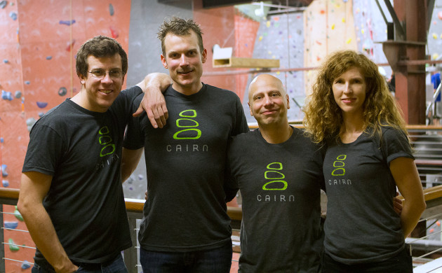
The Cairn team includes, from the left, Nick Neiman, Graham Zimmerman, Ali Alami and Tove Martin. Image via Cairn
The Cairn team includes, from the left, Nick Neiman, Graham Zimmerman, Ali Alami and Tove Martin. Image via Cairn.
Martin and Alami thought up the app when they were out on a hike. After struggling to meet up on the trail, unsure of which way to head for better service, the duo realized they never told anyone where they were hiking to or when to expect them back.
But hiking and spending time outdoors wasn’t just a hobby for the co-founders; Almani was a wilderness survival instructor for the Air Force before he joined Expedia, teaching pilots how to survive if they crash, and Martin directed user experience for Trover, letting travelers share their adventure photos.
The team also includes developer Joel Dubowy, who helps build modeling software for the Forest Service in his day job, helping them to predict the movement of wildfires. And their head developer, Nick Neiman, hiked the Pacific Crest Trail, gathering data and testing the app. Then there’s the professional climber, Graham Zimmerman, who’s helping the team with community outreach and thinking up ways Cairn can benefit pro outdoorsmen.
Alami and Martin bootstrapped Cairn, which launched in December. Alami is working on it part-time while maintaining a product management role at Expedia, while Martin is focusing on the project full time.
The app is free on iOS, but Alami said they plan to build premium offerings in the future for frequent hikers. But now, the team is working on filling out the map and building a robust project to keep hikers safe.
